Bottom Line:
Two rounds of severe weather are possible. Today and again this upcoming weekend. The greatest of the severe threats is likely to be this weekend and it is also likely to be the strongest severe risk we've seen of this spring severe season so far.
Overview:
Today (Thursday)
- Showers and thunderstorms will begin to develop after 12p ET across southern Alabama and move east through the day. Some intensification of these storms through the afternoon could lead to an isolated risk for severe weather. The main concerns would be the potential for isolated damaging wind gusts (40 to 60 mph) and the potential for hail (up to quarter-size). Tornado probabilities are very low but a brief weak tornado can't be ruled out across southeast Alabama this afternoon.
- Activity and severe threat begins to decrease after sunset tonight.
- A marginal (level 1 of 5) risk of severe weather is in place across southeast Alabama, southwest Georgia and portions of the Florida Panhandle.

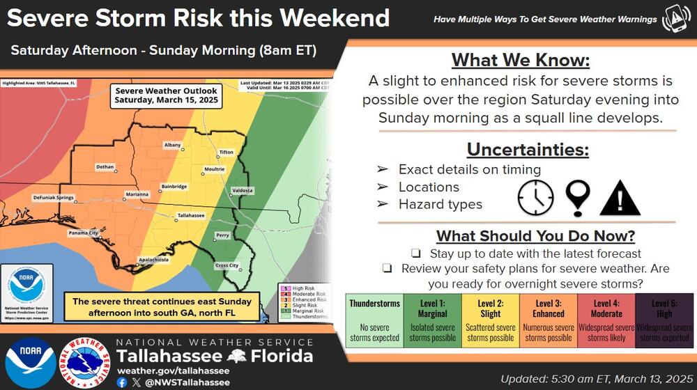
Saturday Evening into Sunday
- A stronger severe threat, likely the strongest of the season so far, will develop Saturday afternoon into Sunday morning as a squall line forms to our west. As this squall line moves east Saturday evening into Sunday morning, scattered to widespread severe weather is forecast along a squall line.
- An enhanced risk (level 3 of 5) is currently in place generally along and west of the Apalachicola/Flint rivers. All modes of severe weather (damaging winds, hail, and tornadoes) are possible. Currently, there is at least a 10% chance of seeing significant severe weather in the enhanced and moderate areas delineated in the attached outlook. Significant severe means the potential for either 2"+ hail, 70mph+ wind gusts, and/or strong (EF2+) tornadoes.
- Some weakening of the squall line is possible as the system moves into south-central Georgia and east of the Apalachicola River, but all modes of severe weather will still remain possible with the main concerns being damaging straight-line winds.
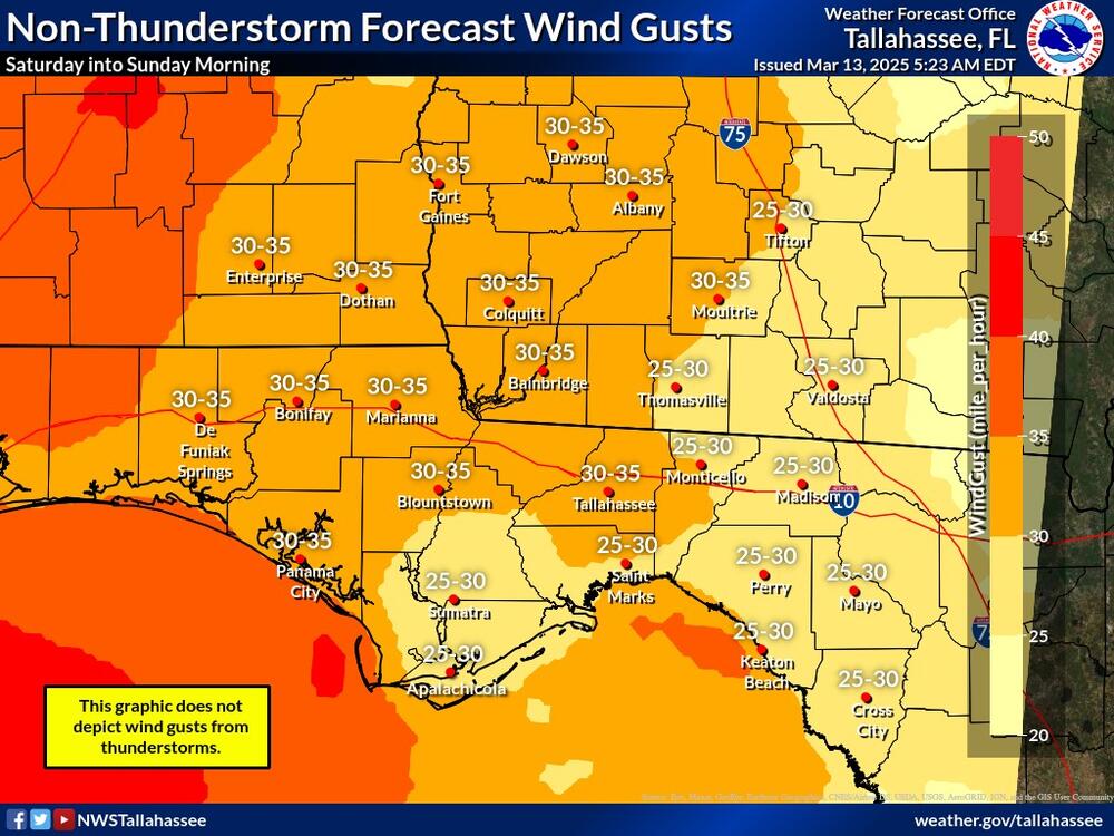
- Strong southerly winds ahead of the squall line are anticipated Saturday into Sunday morning, Sustained winds around 20 mph and gusts of 30 to 35 mph are possible, especially along the coast. Increased surf, life-threatening rip currents (especially for spring breakers), and hazardous boating conditions are expected. Minor coastal flooding (less than 2 ft) with the Saturday evening and Sunday morning high tide cycles is also possible.
- The quick moving nature of this system will keep rainfall amounts generally under 2 inches, but localized flooding can't be ruled out in poor drainage areas Saturday night into Sunday. A marginal risk (level 1 of 4) for excessive rainfall is in place across the entire region.