Good morning,
Bottom Line:
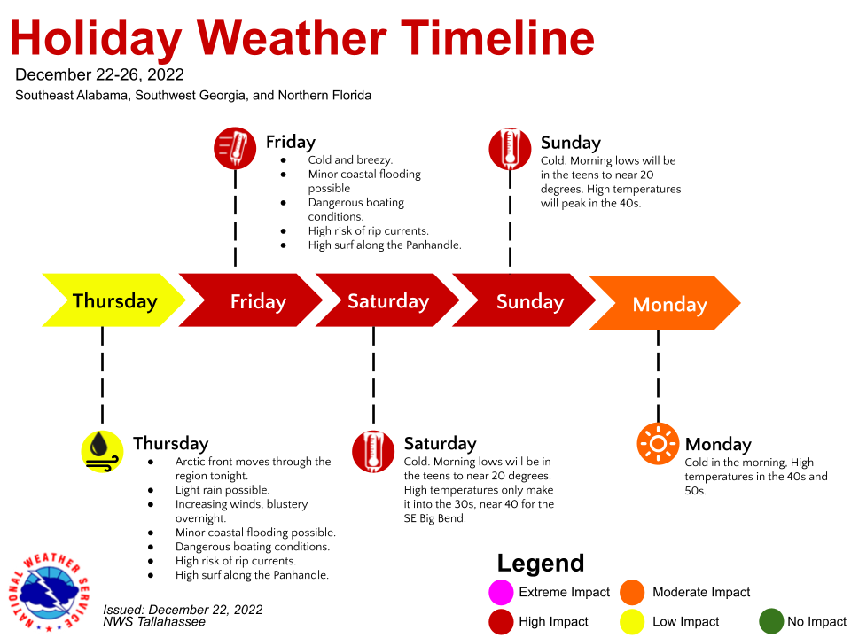
Bitterly cold temperatures, strong winds, and dangerous wind chills are expected across the area after a strong arctic front moves through tonight or Friday morning.
Changes:
- Wind Chill Advisory goes into effect for southeast Alabama, the western FL Panhandle counties, and GA counties west of the Flint River Friday morning. The rest of the counties join Friday evening.
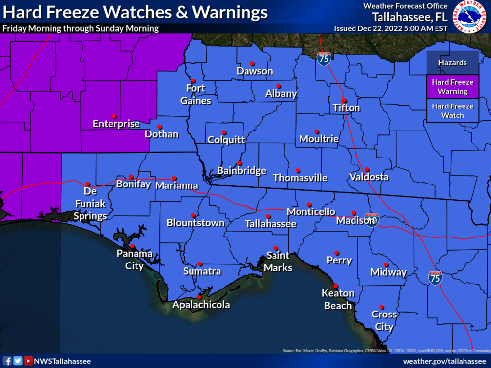
- A Hard Freeze Warning goes into effect for Coffee, Dale, and Geneva Counties for Friday morning.
- A Hard Freeze Watch remains in effect for the entire forecast area Friday night through Sunday morning.
- A Coastal Flood Advisory goes into effect this afternoon for the Emerald Coast and then this evening for the Forgotten and Nature coasts.
- High Rip Current Risk begins this afternoon for coastal Walton, Bay, and Gulf counties.
- A High Surf Advisory goes into effect this afternoon for coastal Bay and Gulf counties
- A Gale Warning is in effect for the entire marine area from this evening through Friday evening.
Overview:
Temperatures:
- Temperatures will sharply fall behind the cold front early Friday morning with a brief hard freeze in southeast Alabama. Temperatures will fall into the 20s and 30s across the rest of the area through Friday afternoon.
- Afternoon temperatures will only be in the 30s Saturday with 40s possible Sunday.
- Hard freezes are expected Friday night through Sunday night across the entire area. Low temperatures Friday through Sunday nights will be in the teens to lower 20s.
- NOTE: Hard freeze conditions are not expected during the afternoon. However, temperatures will struggle to get above freezing Saturday afternoon across southeast Alabama and southern Georgia.
Winds:
- Sustained winds of 15 to 25 mph with gusts of 30 to 40 mph Friday, decreasing Friday night into the weekend.
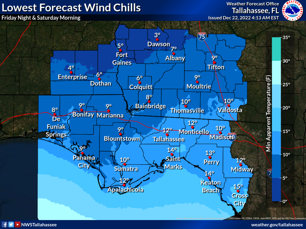
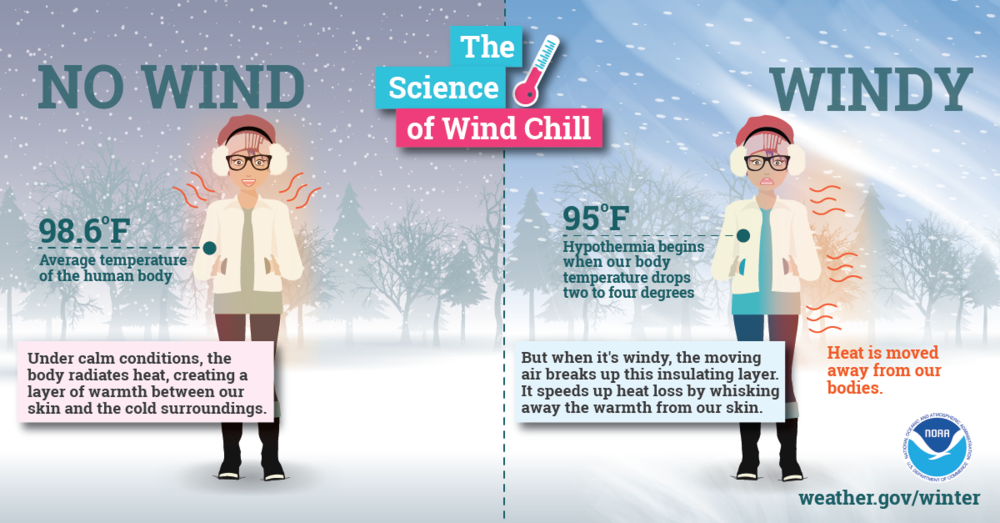
Wind Chills:
- Wind chills Friday morning and afternoon will be in the teens and 20s, falling into the single digits and teens Friday night into Saturday morning.
- Wind chills will become less of an issue Saturday and Sunday as winds subside, though bitterly cold temperatures remain.
Marine & Coastal Impacts:
- Minor coastal flooding is possible along the Panhandle and Big Bend coasts Thursday afternoon through Friday afternoon. Water levels of 1.5 to 2.5 feet above normally dry ground are possible along the Panhandle and western Big Bend coast. Water levels of 2 to 3 feet above normally dry ground are possible along the eastern Big Bend.
- Gale conditions are likely over the waters beginning Thursday evening and continuing through Friday evening.
- There is a high risk of rip currents along Walton, Bay, and Gulf County beaches beginning this afternoon and along Franklin County beaches on Friday.
- High surf of 5 to 7 feet is expected tonight into Friday along Bay and Gulf County beaches.
Fire Weather:
- Gusty winds and minRH values around 25-35% may lead to elevated fire weather conditions on Friday. Fuels across the area seemed to have recovered from the last few rounds of rain, thus we should remain below any watch or warning thresholds.